Normandy

Among all the available options for an invasion of Europe, the disembarkation in Normandy was and is still considered the most promising alternative. In the second half of 1943 began the selection of a disembarkation zone adapted for bringing consistent Allied forces onto the European continent through the English Channel; the research was limited to the west from Brest to the coasts of Holland in the east.
An area that can seem wide, if the overall extension of the Reich’s dominions in that moment are not considered.
The most important influx of provisions from the USA was directed toward the United Kingdom by means of the Atlantic along a route by then trustworthy and so it was a matter of stretching the supply lines to the necessary minimum. Logistical motivations also justified the choice.
An important factor was determined by the total air superiority conquered by the Allies over France. If the efficacy of the Allied strategic bombardments over the industrial zoned of Germany is discussed, certainly the most immediate effect consisted in having forced the Luftwaffe into using its own forces in defense of national territory, withdrawing the squadrons of interceptors from France and Holland toward Germany. This strategic choice offered air superiority in the theater of operations to the Allies. An advantage that absolutely had to be exploited.
Analyzing the coasts of the European continent that appear on the English Channel, Normandy responded completely to the needs of the Allies.
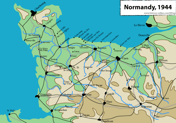
The landing zone was finally fixed in the region of Calvados where the shores of Omaha, Gold, Juno, Sword are found, and at the base of the Cotentin Peninsula where the beach Utah is situated.
The peninsula of Cotentin protects these coasts from the storms that come from the Atlantic, which would have made the landing difficult if it had taken place along the western coast of Cotentin or in another zone further west.
In the immediate interior good communications were present, which would be advantageous for a force in rapid advance and responded to the need of accumulating in the least amount of time possible an invasion force strong enough to resist a counteroffensive.
The shores, moreover, were distant enough from the fortified ports of Cherbourg and Le Havre to evade the long range fire of the coast artillery as they were to consent the occupation within a few days after the landing.
All of the climatic and geographical factors were carefully analyzed by the Allies. The preparation of the landing could count on an enormous quantity of trustworthy and detailed information, provided directly by air reconnaissance, by high points above the shores and by the French Resistance.
An element that escaped the meticulous analysis of the Allies constituted one of the most evident characteristics of the Norman countryside. The fields are bordered by high hedges practically impossible to climb over or pass through and the roads that flank the fields are separated by a dyke; it permits a defender to use the roads as trenches, being able to fire on an open field sheltered by the dyke and camouflaged by the hedges. The training of the troops did not consider this characteristic of the terrain, which in the weeks of war in the interior would cause extremely high losses among the Allies.